Table of Contents
Class Prep
Class 1
Class 2
Class 3
Class 4
Class 5
Class 6
Class 7
Class 8
Class 9
Class 10
>>Topical Articles<<
Assumed Longitude
Bowditch
Bygrave
Casio fx-260 Solar II
Emergency Navigation
Making a Kamal
Noon Sight
Pub. 249 Vol. 1
Sextant Adjustment
Sextant Skills
Sight Averaging
Sight Planning,
Error Ellipses,
& Cocked Hats
Slide Rules
Standard Terminology
Star Chart
The Raft Book
Time
Worksheet Logic
BCOSA.ca
Alert: I just did some work with the anti-spoof app, and the sun altitude it gave was over 1° different from the one I got with my Tamaya. Most likely,
there is a bug in the app...perhaps in its built-in Nautical Almanac. Sometimes the app agrees with my sextant precisely. Other times not. I need to see if I can find a pattern in the weirdness. Ofer, now that we know your basic sextant technique is good, let's think about other uses for the anti-spoof app. The #1 use is for pre-calculating your sights.
That is, it is difficult to find a star in your viewfinder. If you DO find a star, it is easy to have the WRONG star. And even if you do find the right star, it can be
difficult to bring it down to the horizon. Just before you get it where you want it...you lose sight of it through your sextant telescope. Then you have to start all over again
acquiring the star.
A solution to this is to say, "Hmmm...Altair should be around 45° 13' high right now. I will set my sextant to that height, and point it at the
horizon directly below Altair. That should make it eaiser to find." Ofer, the essay below I wrote a few weeks ago. But now let's zero in on action steps.
First, is your GPS being spoofed from the Russian airbase in Syria?
Second, is your height of eye correct? Verify it.
Third, purchase "GPS Anti-Spoof" from the Apple App store. Go with the "Pro" version for US $20.
Be careful when entering the index correction into the app. The Android version can malfunction if you enter a correction of more than ±60.0'. So adjust slowly when you get close to that limit.
If it does malfunction, you may have to uninstall/reinstall the app to get it reset. I have mentioned this bug to the developer, and he promises to fix it soon. One can break
celestial navigation down into two broad skill sets: Developing the worksheet/plotting
sheet skill set is where we will spend much of our class time.
However, coming up with a good fix is built on a foundation of good and
valid sextant observations. If I was teaching you in person, we would both take our sextants to the beach and take sun sights.
I would say, "I have an altitude of 22° 05.4'. What do you have?"
If one of us got a significantly different reading from the other, we
would investigate further to see where the problem lay. But this
is not possible when the teacher is in Canada and the student is in Israel. That being the case, there is an
application that you might find helpful: GPS Anti Spoof.
You can get it in the
plain vanilla version (for $5 US) or the
pro version (for $20 US). For our purposes, the less expensive
version will work just fine. What the app does is to figure out
where you are using GPS. It has a full, built-in Nautical Almanac
and digital equivalent of Pub. 249, and it calculates: based on
where you are and what time it is, and what celestial object you are
looking at, what sextant altitude ought you be getting. As
Frank Reed, the app author, says
here: The app calculates a live
sextant altitude, exactly as it should appear on the instrument,
from the current GPS position. The app has two basic functions. 1: TRUST THE SKY: If
you're a reasonably skilled celestial navigator, and your position
is mission-critical, then the app is a sensitive, accurate test of
the GPS position. If your position is being spoofed by criminals,
pirates, military or government intelligence forces, you can detect
that with an easy, quick sight of your favorite celestial body. An
observed celestial altitude will not match the app's calculated
altitude if you're being spoofed. You can detect GPS Spoofing at sea
using this app. At this stage of your career, you
are primarily looking to trust the GPS, and use it to correct your
sextant technique. Now, I read perhaps 2 weeks ago
that Ben Gurion Airport in Tel Aviv was telling pilots to not use
GPS on landing approach, as the Russians were spoofing/skewing GPS in
Israel from an airbase in Syria. So before you use this app, you
should verify that your GPS is giving you good results that day.
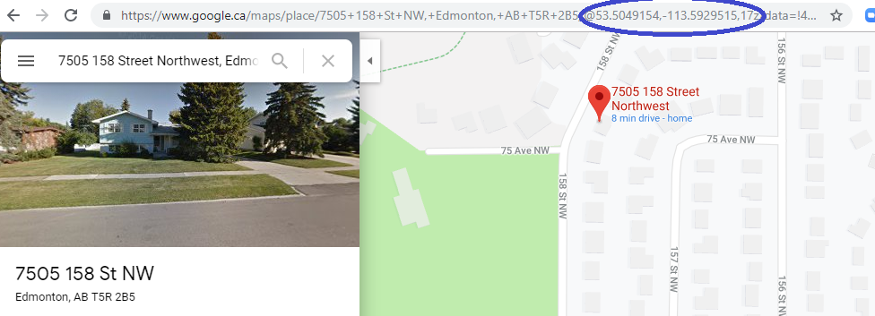
Either use Google Maps (which will give you your latitude/longitude in
decimal format in the address bar, like this for my parent's old house
here in Edmonton, 8 minutes from my house:
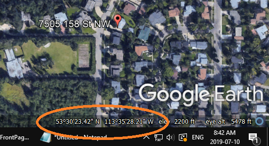
OR you can download and use Google
Earth, which gives you the latitude/longitude in conventional
navigator's notation, down in the lower right corner.
Using whatever tool you wish,
verify that GPS is accurate in your area - at least at the moment you
did your check - before driving down to the beach. If your GPS is
accurate, then this will app become a great teaching tool to help you
confirm you are using your sextant properly. On the settings screen, indicate
the object you are viewing, whether you are viewing upper limb or lower
limb, and the type of horizon you are using (the two options relevant to
you and I are either a sea horizon or an artificial horizon/mirror).
Enter your index correction and height of eye. The delay is so if
you are taking sights by yourself, you can cause the altitude display to
offset by some number of seconds, to give you time to get your eye away
from the sextant and looking at your phone. If I am just checking my
sextant use, I don't need enormous accuracy from the app. In
the second or two that it takes me to look at my phone's screen, the
altitude of the sun changes (almost) not at all. I am pretty confident about my
sextant technique. Where I have used this app is in verifying
that the mirror I am using as an artificial horizon is perfectly
level. If it IS level, then my sextant should read what the
app reads. If the two differ by much, it tells me I need to
spend a bit more time using my machinist's level to iron out my
mirror problems. At this point, I am trying to level the
mirror by slipping playing cards and pieces of paper under this edge
or that of the mirror. It is not a very precise process.
One of these days, I may splurge and buy a levelling platform such
as chemical laboratories sometimes use. The app will download temperature
and barometric pressure data if it has data access via your phone.
"DOV" is "deflection of vertical". It is a way of bringing even
more concordance between your sextant sight and GPS. If there is a
local skewing of gravity, such that it does not point directly
down at the center of the earth, this app will correct for that. The biggest DOV corrections are in
the Caribbean - the islands of which are basically big volcanos.
These volcanos have so much mass that they skew the direction of gravity
a bit, sucking the sea water up toward them a bit...basically tilting
the sea horizon. In that part of the world, you can get up to a 1
or 2 nm error due to DOV. It is possible that if you are
standing on the beach at Tel Aviv looking west, you have the Dead Sea at
your back: an absence of rock that would normally be there
if the land was flat. I don't know if you have any DOV issues in
Israel. But since the errors are guaranteed to be less than 2 nm -
and probably less than 1 nm - and my personal sextant errors are often 3
miles, any DOV issues are normally lost in the noise of me and my
sextant bouncing in the waves, and distortions of the horizon due
to weird refraction. That being said, this app corrects
for DOV. In either class #1 or class #2, we
will make adjustments to your sextant. Once we dial out the
problems there, if you are still getting sextant altitudes that
translate into 20+ nm error on a consistent basis, you might consider
purchasing a copy of this app as a digital teacher of sorts. The time displayed in this app is
set to GPS-based UTC time...actually, to GMT (which it different
slightly right now from UTC). It is quite an elegant app.
2: TRUST THE GPS: Turn it around. If you're learning or
improving your sextant skills in circumstances where your position
is not yet mission-critical and you have a reasonable expectation
that the GPS position is near-perfect as usual, then the app is a
sight-trainer, an instant check on your instrument and your skill
using it. Shoot the Sun and compare. No paperwork at all. When
learning, this also cleanly separates the two sides of the process
of learning celestial navigation. You can quickly ramp up your
skills using a sextant with the instant feedback from this app. Save
the math for another day.