Table of Contents
Class Prep
Class 1
Class 2
Class 3
Class 4
Class 5
Class 6
Class 7
Class 8
Class 9
Class 10
>>Topical Articles<<
Assumed Longitude
Bowditch
Bygrave
Casio fx-260 Solar II
Emergency Navigation
Making a Kamal
Noon Sight
Pub. 249 Vol. 1
Sextant Adjustment
Sextant Skills
Sight Averaging
Sight Planning,
Error Ellipses,
& Cocked Hats
Slide Rules
Standard Terminology
Star Chart
The Raft Book
Time
Worksheet Logic
BCOSA.ca
Differences and Similaries in How People Approach Celestial Navigation
Terminology
In the English-speaking world, there is near universal acceptance of the terminology and abbreviations for:
- GP
- GHA
- DR
- AP
- Fix
- COP
- LOP
- Ho
- Hs
- Z for Azimuth Angle
- Zn for Azimuth
There is some variation in how the meridian angle is abbreviated. Older books on navigation will abbreviate it as:
- t
...which was used because people thought of time and degrees-of-movement-by-the-sun as being equivalent concepts. Hence 4 minutes of time and 1° of arc angle described the same distance across the face of the earth
Modern works will abbreviate it as:
- MA
- LHA (for Local Hour Angle)
Bob is inconsistent...possibly because of having read both newer and older navigation books. So he will use t, MA, and LHA interchangeably.
Technically, t and MA are two ways of referring to an identical concept, while LHA is slightly different. Please be patient. We will get into subtle differnces later in the class. "Who is the hero? The one who controls his passion."
Plotting
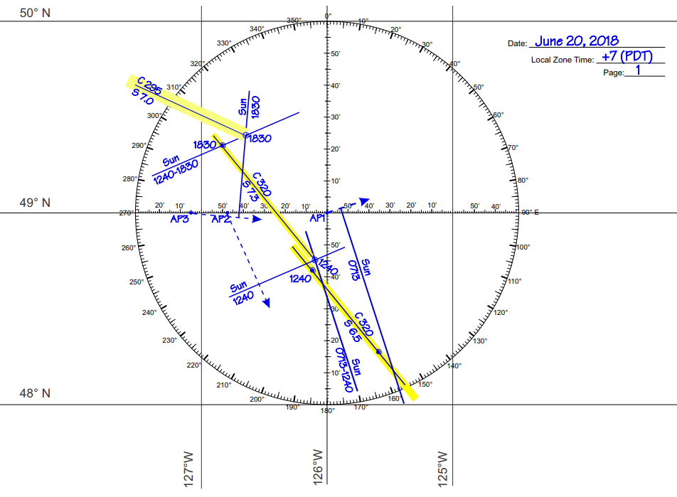
There is a broad consistency in how data is presented on a plotting sheet. Broad consistency...but no universal, fixed standard. The key point is that HOWEVER you choose to plot your data, you should be consistent yourself, and whatever you do should be crystal clear to the next navigator who comes along.
Bob uses a plotting standard that is derived from Bowditch, a hugely influential handbook of navigation published by the U.S. Government. It is the standard encyclopedia of navigation in the US and Canada. (I am not sure how much it is used in Great Britain.)
The standard is described an illustrated on page 2 of the universal plotting sheet that we will use in class.
The one departure from Bowditch that Bob likes to use is to emphasize course lines with a yellow highlighter. This ensures that of the three sorts of lines that occur on a plotting sheet:
- course lines (solid line highlighted in yellow)
If plotting onboard a small boat, getting water on the paper is always a possibility. The ink from most yellow highlighters will run if this happens. You can get a yellow highlighter that uses permanent ink here. - azimuth lines to celestial object (dashed lines with an arrow at one end, pointing to the celestial object)
- lines of position (LOPs - solid lines)
...each is visually distinct from the others.
Looking at our textbook by David Burch, on page 148, you can see that he uses the same line type for every kind of data.
Certainly a navigator ought to be able to look at one of David Burch's plots and make sense of it...but
Bob likes his plots
better. ☺
Sight Reduction Worksheet
There is zero standardization here. Every instructor seems to have his own format for a worksheet, and Bob is no exception.
Believing that it was probably less confusing for the student if he could use the same worksheet as he finds in his textbook, Bob certainly started out using the worksheet found in your textbook on page 278.
However, the class Bob did last year with Carly (an artist) and Bill (a dyslexic) led to Bob gradually
redesigning his worksheet in a way that made it easier for Carly to comprehend, and Bill to use with a minimum of numerical errors. So what we will be using in this class is
this worksheet that has evolved over time, but
started its life as identical to David Burch's worksheet. General Celestial Navigation Method, and Specific Sight Reduction Method For several centuries, the practice was to calculate a fix based on the dead reckoning position. This approach was, by modern standards,
tedious and error-prone.
Without a good idea of the time,
knowing your longitude is impossible. So the problem of coming up with a fix was exacerbated by (prior to 1759) the non-existence or, alternatively (prior to 1850), the high
cost of marine chronometers. When Captian Cook sailed to Tonga in 1777 with a chronometer supplied by the Royal Society, the value of the timepiece exceeded that of the rest of the
ship and its stores. Consequently, it was a common practice to "sail down a line of latitude" e.g. if you wanted to end your voyage in Cadiz, Spain, you got yourself onto a latitude of
36° 31.8', and headed east. You couldn't possibly miss Cadiz this way. The type of sight you used for this type of sailing was the noon sight...which gives you an accurate
idea of your latitude, but no input at all on your longitude. Sailors are a notoriously conservative group of people, and even to this day, we find the noon sight is chapter 3 in David Burch's textbook. But in 1875, a French naval captain named Marcq St. Hilaire came up with the innovation that if one modified the DR latitude so that it landed directly on a whole degree (e.g. 52° 00.0'
rather than 51° 43.8') and modified the DR longitude so that it was a whole number of degrees from the GHA (e.g. if the GHA is 75° 22.5' and the DR longitude
is W 113° 38.5', then modify the DR longitude so it has the same number of minutes as the GHA, thereby making the MA a whole number of degrees - hence in this case, the DR would
become 113° 22.5'), the whole process became much easier. You could calculate a hypothetical sextant observation for this hypothetical location (called an Assumed Position or AP),
and then compare this hypothetical observation ("Ho") with your actual sextant height (Hs) and determine how far your fix is from the AP. Don't concern yourself too much in understanding the paragraph above. Determining how to use the St. Hilaire Method is what we we spend much of the next
30 hours of this class. It is also the focus of our textbook by David Burch in chapters 5 to 9. Using an AP rather than a DR made navigational math dramatically easier. Books
of navigational tables became thinner. And with the St. Hilare Method, you could take a sight any time of the day, rather than waiting for noon...and hoping that the clouds did not
obscure the sun at a critical moment. The advantages of this method are significant, and are outlined here.
An additional advantage was that you could use this sight with stars or planets...which led
to twilight (either just before dawn, or just after sunset) becoming the prime time during the day for doing sextant sights. If you take sights on
two objects within a minute or two of each other,
you can get two LOPs that cross and have yourself an immediate fix. There are several methods of implementing the St. Hilare Method (also known as the Intercept Method) at a practical level: The US Navy has a policy of keeping a copy of all six volumes of Pub. 229 on the bridge of every ship. For reasons
discussed here,
the near universal practice of yachtsmen is to use Pub. 249.
The only exception to the general usage of Pub. 249 would be navigators trained by the United States Power Squadrons...who have a preference for using calculators and trigonometry. Bob's perspective is that you lose much of the advantage of celestial navigation, for instance in the event of a lightning strike, if you require the use of an electronic calculator.
Hence, in Bob's classes the use of the St. Hilaire Method, with Pub. 249, is taught as the primary technique. Toward the end of the course, we will touch on noon sights and Polaris sights, but more as historical curiosities than as primary techniques for use today.